
USDOT Acts After Troubling Road Fatality Data; Iteris’ New Speeding Analytics Can Help
 3 min. Read
• Posted
12/02/2021
by
Jeff Venables
3 min. Read
• Posted
12/02/2021
by
Jeff Venables

Following the largest six-month increase in traffic fatalities ever recorded, the United States Department of Transportation (USDOT) has announced the release of its first-ever National Roadway Safety Strategy.
The National Highway Traffic Safety Administration (NHTSA) estimates that 20,160 people died in motor vehicle crashes in the first half of 2021; the number represents an increase of 18.4% over 2020 – and is the largest number of projected fatalities within a single half-year since 2006.
A tandem driver-behavior study also just released by the NHTSA finds that from March 2020 through June 2021, incidents of speeding were higher than pre-pandemic levels.
The new USDOT initiative will identify actions to take to promote safer people, roads, vehicles and speeds, as well as post-crash care.
Smart mobility speeding analytics
Iteris’ ClearGuide® smart mobility software helps agencies make the best traffic operations and planning decisions by analyzing large amounts of complex transportation data to identify and visualize problem areas before traffic congestion worsens.
Now, ClearGuide offers a new Speeding Analytics module that can help agencies deliver on the federal government’s new roadway safety initiative.
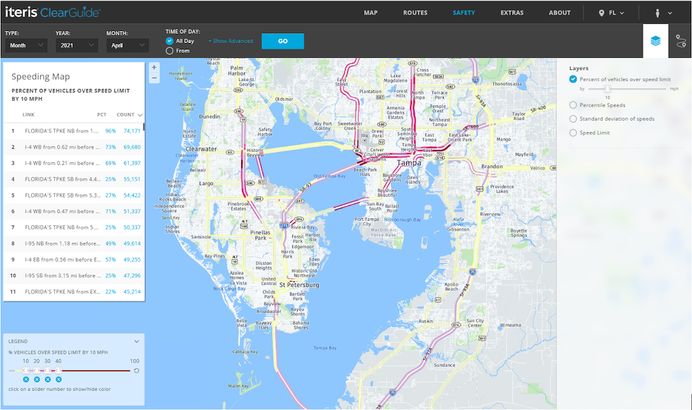
The Speeding Analytics module helps agencies proactively identify and rank regional speeding hotspots before crashes occur. The module’s speeding map lets users identify and rank speeding hotspots on the roadways that are relevant to them. Users can customize the map to pull data from different time ranges and can filter by days of the week, times of the day, and roadway types.
The map provides different layers for different insights into speeding problems. The main view shows the percent of vehicles over the speed limit by a user-customizable threshold (e.g., over 10 mph) to identify locations with significant speeding behavior.
Moving past subjective assessments
The speed summary for links and corridors includes data for every fifth percentile; the maximum and minimum speeds for each sample set; and ordinary free-flow speed, which can be more valuable than simply comparing motorists’ speeds against the posted speed limit.
Other layers include the standard deviation of speeds, to identify roadway locations where speed variability may cause safety issues; and speed limit, for quickly visualizing the posted speed limit on the roadway and correlating with speeding behavior.
The new module was designed for state, county and city DOTs and MPOs, and uses high-resolution GPS probe data to visualize and quantify speeding problems across the roadway network. The module solves the problem of limited, static and outdated speeding data collected with radar. It eliminates any reliance on anecdotal reports of “fast driving.” It can also complement crash software systems through the data export feature.
 X
(Twitter)
X
(Twitter)
 Facebook
 LinkedIn
 Copy
Link
Copy
Link Email
EmailPost Topics
Related Posts

Prep for and Manage Back-to-School Congestion Changes with Iteris ClearGuide
4
min. Read
• Posted
08/25/2026
by
Jeff Venables

Watch: Why the Future of Transportation Depends on Hardware and Software Working Together
2
min. Read
• Posted
08/11/2026
by
Ahmad Jawad

What’s Driving the DRAM Shortage – And What It Means for Transportation Technology
4
min. Read
• Posted
07/23/2026
by
Todd Kreter